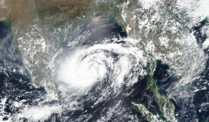
A rapidly intensifying weather system over the Bay of Bengal has now been designated as Cyclone Montha, and is forecast to make landfall near the Andhra Pradesh coast by October 28, 2025. The India Meteorological Department (IMD) has issued red‐alert warnings for coastal districts, especially between Kakinada and Machilipatnam, urging residents, fishermen, and authorities to adopt heightened vigilance.
In this article, we unpack the latest tracking data, key warnings, potential impact zones, and what you should know—even if you’re not on the coast.
Storm Track & Intensity Forecast
According to the IMD, a low‐pressure area over the south-east Bay of Bengal has strengthened into a depression and may intensify into a severe cyclonic storm by October 27.
Some key numbers:
Winds estimated at 70‐80 km/h, with gusts up to 90 km/h already across the region.
Forecasted landfall zone: between Machilipatnam and Kakinada along the Andhra coast.
Time of landfall: Early next week (around October 28) with heavy rainfall expected from October 27 onwards.
Meteorologists highlight that the warm sea-surface temperatures and moist air over the Bay of Bengal create an ideal environment for this storm to strengthen.
“A low-pressure area has already formed and is likely to strengthen into a deep depression by October 26, and then into a cyclonic storm…,” according to IMD bulletins.
Areas Most at Risk & Preparations Underway
The coastal districts of Andhra Pradesh are on the front line, with neighbouring Tamil Nadu and Puducherry also under alert for heavy rains and thunderstorms.
The Andhra Pradesh Chief Secretary has directed all district collectors to activate control rooms, keep shelters ready, ensure uninterrupted power/mobile networks, clear fallen trees, and evacuate vulnerable groups (including pregnant women in islands/coastal villages).
Fishermen have been strictly advised not to venture into the sea after October 26. Wind warnings and rough sea conditions pose a grave risk.
Meteorological forecasts call for heavy to extremely heavy rainfall in parts of coastal Andhra from October 27 onward.
H2: What Could Happen – Impact Scenarios
While the exact ground impact will become clearer after landfall, here are what experts anticipate:
Rainfall & Flooding
Heavy rainfall may lead to flash flooding, waterlogging in low-lying areas, overflow of tanks or canals, particularly near coastal mandals. Monitoring of water bodies has been emphasised.
Strong Winds & Storm Surge
With gusts potentially above 90 km/h, expect uprooting of trees, damage to weak structures, and possible storm surge along the coast. The sea will remain very rough—stay away from the waterline.
Disruption to Services & Transport
Power outages, mobile network disruptions, blocked roads due to fallen branches are likely. Coastal evacuation routes may be under pressure. Authorities have asked for high readiness for such disruptions.
Secondary Effects
Schools may be closed, public transport may see delays, local fisheries will be affected, and livelihoods in coastal fishing villages may be temporarily disrupted.


